eXplorist 210 - Magellan GPS
Magellan - explorist210 satellite handheld GPS unit is powerful, affordable GPS with track-plotter. Explorist-210 provides reliable accuracy to within 3 meters. Save track logs to guide you to your favorite spots. Back Track will lead you to camp, the car and home. ![]()
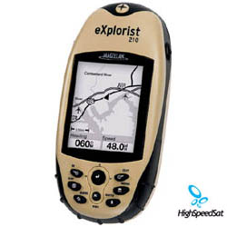
The Magellan® eXplorist™ 210 proves that powerful and reliable GPS navigation can be affordable. With a compact, shockproof and water resistant design, this baby is built to withstand whatever the back country can throw at it. At a mere 6.1 ounces, and with the ability to download and store up to 22 megabytes of maps while providing precise three-meter positioning, this pocket-sized 14-channel WAAS GPS receiver is an outdoors enthusiast's dream.
If you have a passion for the outdoors, there's no reason you need to be a GPS expert to be able to take advantage of GPS tracking capabilities. The eXplorist 210 features Magellan's easy-to-use operating system, so you can concentrate on your activities without compromising your safety. When you connect the unit to your PC, the folders on the eXplorist 210 can be accessed just like any drive on your computer, and from there you access the information as you would a folder on your own computer. In other words, if you know how to navigate your PC, you'll feel right at home with the eXplorist 210.
The unit offers 32 MB of memory, which includes 10 MB taken up by the basemap of major highways, airports, interstates, parks, rivers and lakes across North America. The remaining 22 MB is reserved for you to download and store Magellan MapSend programs and maps, or specific waypoints, routes and tracks for your next excursion. A USB PC cable is included, which will allow you to perform software updates, as well as download additional maps. This convenient feature allows you to download exactly the maps and data that you need for your excursion. If you're hiking a section of the Grand Tetons, you'll want to have the area's hiking trails, ranger stations, and elevation contours at your disposal. The eXplorist 210 lets you fine tune the data that you'll need for your trip.
explorist 210 device
in the box ![]()
And don't let its compact size fool you. This handheld -- at a mere 2.2 x 4.75 x 1.3-inches (W x H x D) -- will let you create and store up to 190,000 personal points of interest and waypoints, 150 files with 20 routes each, and 150 track logs with 2,000 points each. The included Magellan MapSend Software DVD will help to optimize and manage your data and keep track of updates to new versions of MapSend maps. In other words, Magellan couldn't have made it much easier than this.
The eXplorist runs on two AA batteries that last up to 17 hours. A large, 2.3-inch grayscale, backlit display features an amber glow that makes it easy to read at night. Other features include a vertical profile, a celestial table, and a best-fish and hunt-time calculator. The eXplorist 210 comes with a one-year manufacturer's warranty.
Magellan explorist 210 Hand held GPS Receiver Review
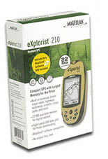
Magellan's latest hiker's guide will put you on the map. The Magellan Explorist 210, with the most memory in its class, gives you the ability to easily download and access multiple map files, and delivers the best value in Mapping GPS. A compact, rugged, easy-to-use GPS unit, its IP-X waterproof and rubber armored container makes it an indispensable companion for all outdoors expeditions. Save 150 Track Logs each with 2000 track points Advanced PC-style File Memory system New Geocaching File Manager software Uses 2 AA batteries for 18 hours of power IP-X Waterproof and Rubber Armored High-speed USB data port Full Keyboard with joystick for 1-Touch access to key features Compatible withh Magellan MapSend software products.
Magellan explorist 210 ![]()
Magellan has expanded their eXplorist series by adding the eXplorist 210 handheld GPS mapping system. Magellan has given the eXplorist 210 the same lightweight, compact design as the rest of the eXplorist series so it can easily fit in your pocket. At a mere 5.8 ounces, the 210 will not weight you down on your next Hunting, Hiking or Geocaching adventure. The eXplorist 210 has a 1.8 x 1.4 display that features a two level backlight with an amber glow so it is easy to read during nighttime use. The eXplorist series all feature Magellans easy to use operating system, so that even a novice can start navigating right away. Magellan has included 32 megabytes of memory on the eXplorist 210. The internal basemap of the eXplorist 210 takes up 10 of the 32 megabytes; the basemap includes major highways and interstates as well as large lakes and rivers across the North America. The 22 megabytes that is left is for you to use for storing detailed maps from optional Magellan Mapsend programs, as well as file storage of waypoints, routes and tracks. The file storage feature allows you to show folders, just like you have on a PC that contain your waypoints, routes and tracks. When connected to your PC the folders can be accessed just like a drive on your computer to show your folders and files.
GPS eXplorist Specification
| Technical Specifications | |
|---|---|
| Physical: | |
| Case: | Rubber armored impact-resistant plastic, water-resistant seal |
| Base Map: | None |
| Size: | 2.2" W x 4.7" H x 1.3" D (W 5.6 cm x H 11.9 cm x D 3.3 cm) |
| Weight: | 5.8 oz (164.4 g) - w/ batteries |
| Display: | 2.25" diagonal, 4-level grayscale, high resolution (122 x 160), backlit |
| Memory: | 4 MB user data |
| Data Storage: | None |
| Antenna: | Built-in multidirectional patch |
| Keypad: | Nine direct-access keys |
| Joystick: | Eight-way easy scrolling w/ push-in instant enter |
| Operating Range: | 14 to 140°F (-10 to 60°C) |
| Performance: | |
| Receiver: | TrueFixTM 14 channels, WAAS/EGNOS |
| Acquisition Time: | Hot: 20 seconds, Cold: 60 seconds, Initial: 2 minutes |
| Update Rate: | Once per second |
| Accuracy: | 3 to 5 meters (10 - 16 feet) - WAAS/EGNOS, < 7 meters (15 feet) - GPS only |
| Velocity: | 0.1 knots (RMS) |
| Dynamics: | 6 g |
| Grids: | 75 including Lat/Lon, UTM, OSGB,MGRS, Finnish, German, Swedish, French, Irish, Swiss, USNG, 1 User Grid (76 Max) |
| Languages: | English, French, German, Spanish, Italian, Swedish, Finnish, Portuguese, Dutch, Norwegian |
| Power: | |
| Source: | Two AA batteries |
| Battery Life: | Up to 18 hours continuous use |
More Magellan GPS related links:
Magellan Products - Auto, handhelds, fitness, portable gps devices and accessories.How GPS works? - A lot of details about GPS system.
GPS satellites - NAVSTAR, satellite constellation, USCG Navigation Center and more!
GPS Blog - Comment the latest news and info from gps arena
GPS Satellite Forum - Raise a topic with other GPS enthusiasts about products, software, applications or adventures.
GPS Unit Documentation and Manuals
Click onthe thumbnail to download
Explorist Magelan 210 GPS
Reference Manual
(PDF, 1,588K)