eXplorist 500 LE - Magellan GPS
The Magellan eXplorist500 - Navigate in color! High-speed USB port and unlimited SD card data storage make it easy to add detailed maps, for topo, marine or street navigation. Save track logs and more to 8 MB free memory.![]()
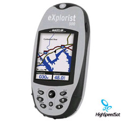
Outfitted with a 16-color display, a high-speed USB data port, 8 MB of built-in maps, and an additional 8 MB of usable memory, the Magellan® eXplorist 500 North America includes all the tools you need to navigate throughout the U.S. and Canada whether in the car or on foot. The device is rugged and lightweight, with a waterproof, impact-resistant plastic housing that stands up to almost every adventure, including whitewater rafting and hiking. At the same time, its pocket-sized chassis, which measures a mere 2.2 by 4.7 by 1.3 inches (W x H x D), is loaded with convenient features, such as detailed, built-in maps of North American roads, parks, waterways, and airports; the ability to save five track log files, 20 routes, and 500 points of interest; and an area calculator that determines the distance between saved points of interest--an ideal function when mapping out hiking trails. Other cool and convenient add-ons include a fish/hunt function that mentions the best fishing and hunting times for a specific coordinate and a similar tool that displays the rising and setting times for the sun and moon.
Should the built-in maps and extra memory prove insufficient, users can load additional map data onto Secure Digital (SD) memory cards using Magellan's MapSend software (sold separately), which is available via CD-ROM and, in some cases, online (your computer connects to the GPS through its USB port). There's no limit to the number of cards you can use, giving users access to everything from detailed street maps to topographical layouts to lake charts showing bottom features and boat ramps. Fun seekers will also delight in the Geocache Manager, which invites individuals and families to download geocache coordinates from specific Internet sites and use them on such adventures as treasure hunts and coordinated community projects. The manager employs a PC-style file system to keep geocache navigation easy.
Adding to the simplicity are the intuitive keypad and joystick controls, along with the one-button access for particularly important features. Unlike with many GPS systems, it doesn't take an expert to start navigating right away. The full-color display also helps first-time users, as it's easier to differentiate between different map features and data.
EXPLORIST 500 device
in the box ![]()
You can buy your gps receiver with additional features that include multilingual communication (choose from English, French, German, Spanish, Italian, Swedish, Finnish, Portuguese, Dutch, or Norwegian); four navigation screens for viewing speed, direction, distance to destination, and more; and a rechargeable lithium ion battery pack that keeps the eXplorist 500 portable working for up to 17 hours. Conveniently, users needn't remove the battery to charge it; simply plug the charger directly into the receiver and it renews itself.
The eXplorist 500 North America Handheld GPS is low price gps and your all-purpose guide to the wild, untamed natural wonder on the North American continent. Its 8 MB of built-in maps and an intuitive interface make it easy to start navigating right out of the box. Save 5 track log files, 20 routes and 500 points of interest to the 8 MB of additional internal memory - or store as many more as you want on optional SD cards. The color backlit LCD screen makes it easy to navigate, even in the dead of night. Geocache, TrueFix and Area/perimeter calculations help you find your way anywhere on the continent. Ready to go with no service or activation fees Unlimited SD Card expandability - add detailed street maps or topo charts with the optional Magellan MapSend software TrueFix GPS technology uses 14 parallel channels Download Geocache coordinates from Websites and manage travelling more effectively Area & perimeter calculation for the distance between two waypoints Monitor satellite status while tracking your position Rubber armored, impact resistant plastic for safe carrying on every adventure Watertight - sealed to IPX-7 specifications.
Magellan eXplorist 500 Review
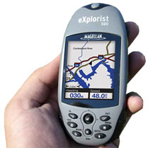
Handheld GPS in hand
Magellan/eXplorist 500
![]()
The eXplorist 500 has an 8MB basemap with major roads as well as major Points of Interest, and that mapping can be expanded with the purchase of compatible Magellan Mapsend software and a SD memory card. The eXplorist 500 can use the SD card to store maps as well as an unlimited amount of waypoints, track logs, and routes. The eXplorist 500 has a Li-Ion rechargeable battery pack that can provide up to 14-hours of use and comes with a USB interface cable so you can transfer information at high speeds. Just like the rest of the eXplorist line, Magellan has made the operation simple so just about anyone can use it; there is even a Geocache Manager to easily manage your geocaching coordinates. The eXplorist is built for all outdoor adventures with its waterproof casing, rubber armor and impact resistant plastic. Other features include Area Calculation function, 10 Languages, and four navigation screens. 1-Year Warranty. Size: 4.6"H x 2.1"W x 1.3"D. Weight 4.6 oz. One-year warranty.
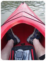
EXPLORIST 500 personal navigator in kayak. ![]()
With 8 MB of built-in North American or European maps it's easy to navigate around roads, parks, waterways and to find airports and other points of interest.
Download geocache coordinates from Internet sites and use them on your outdoor adventures. This unique feature makes managing coordinates even easier with a PC-style file system. You don't have to be a geocacher to appreciate the Magellan Geocache Manager.
GPS eXplorist Specification
| Technical Specifications | |
|---|---|
| Physical: | |
| Case: | Rubber armored impact-resistant plastic, water-resistant seal |
| Base Map: | Built-in basemap of North America or Europe |
| Size: | 2.2" W x 4.7" H x 1.3" D (W 5.6 cm x H 11.9 cm x D 3.3 cm) |
| Weight: | 5.4 oz (164.4 g) - w/ batteries |
| Display: | 2.25" diagonal, 16-color transflective TFT, high resolution (122 x 160), backlit |
| Memory: | 16 MB user data |
| Data Storage: | Unlimited / Secure Digital (SD) Card compatible |
| Antenna: | Built-in multidirectional patch |
| Keypad: | Nine direct-access keys |
| Joystick: | Eight-way easy scrolling w/ push-in instant enter |
| Operating Range: | 14 to 140°F (-10 to 60°C) |
| Performance: | |
| Receiver: | TrueFixTM 14 channels, WAAS/EGNOS |
| Acquisition Time: | Hot: 20 seconds, Cold: 60 seconds, Initial: 2 minutes |
| Update Rate: | Once per second |
| Accuracy: | 3 to 5 meters (10 - 16 feet) - WAAS/EGNOS, < 7 meters (15 feet) - GPS only |
| Velocity: | 0.1 knots (RMS) |
| Dynamics: | 6 g |
| Grids: | 75 including Lat/Lon, UTM, OSGB,MGRS, Finnish, German, Swedish, French, Irish, Swiss, USNG, User Grid (90 Max) |
| Languages: | English, French, German, Spanish, Italian, Swedish, Finnish, Portuguese, Dutch, Norwegian |
| Power: | |
| Source: | Li-Ion rechargeable battery 1300 MAH |
| Battery Life: | Up to 17 hours continuous use |
More Magellan GPS related links:
GPS Blog - Comment the latest news and info from gps arenaGPS Satellite Forum - Raise a topic with other GPS enthusiasts about products, software, applications or adventures.
GPS Unit Documentation and Manuals
Click onthe thumbnail to download
Explorist Magelan 500 GPS
Manual
(PDF, 3,239K)