explorist XL - Magellan GPS
Magellan - exploristXL satellite handheld GPS unit is powerful, affordable GPS with track-plotter. Explorist-xl provides reliable accuracy to within 3 meters. Save track logs to guide you to your favorite spots. Back Track will lead you to camp, the car and home.![]()
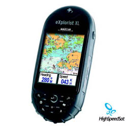
New Magellan® eXplorist XL handheld GPS the advanced, yet easy-to-use Magellan eXplorist XL ensures navigators can easily see where theyre going with the largest screen available on a rugged handheld GPS -- a 3.5, sunlight viewable, high contrast color TFT LCD screen. It also delivers unlimited map storage with 30MB of available internal memory plus expandable memory through a built-in SD card reader/writer. The Magellan eXplorist XLs enhanced capabilities offer exceptional versatility for camping, boating, fishing, hunting or driving.
Weekend warriors find yourselves on the map in living color with the largest color screen in a rugged GPS handheld. The easy-to-use eXplorist XL delivers quick access to key features, plus limitless map storage via the built-in SD card reader/writer. 14 parallel channels with WAAS enabled Back-lighted keypad with Joystick on front housing Easy switching between map files. In a few clicks, change from Street maps to Topo maps to Lakes maps. Dimensions (HxWxD) - 6.4x2.9x1.33
Magellan eXplorist XL
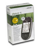
device in the box ![]()
Magellan has taken every GPS users wish list and packed it all into their latest handheld GPS, the eXplorist XL. With its 3.5" sunlight readable color display, the eXplorist XL is easy to see in any lighting situation. Magellan has also included their TruFix technology, which features a 14-channel WAAS receiver for fast acquisitions and accuracy down to 9 feet. The entire Magellan eXplorist series features an easy to use operating system so even a novice can pick it up and start navigating. The eXplorist XL has an included 28-megabyte built-in basemap that includes maps of major highways and interstates as well as major lakes and rivers throughout North America. The Magellan eXplorist XL also has an SD storage card slot so you can expand the storage capabilities of the eXplorist XL to hold additional map downloads from the optional Mapsend CD-ROM's. The eXplorist XL is great for road trips, both in a Car and on a Motorcycle; the large color display makes it easy to see where you are going. The Magellan eXplorist is also great to bring with you on your next hiking or hunting trip, it is waterproof to IPX 7 standards and has rubber armor to make one extremely rugged GPS unit. The Magellan eXplorist XL can also easily switch between different map files depending on your application. For example, if you have Topo maps and Street Maps loaded to an SD card the unit can easily toggle between the two different map files. If you are using the eXplorist XL for Geocaching, Magellan has included their new Geocaching Manager software to keep track of all of you caches.
The advanced, yet easy-to-use Magellan eXplorist XL ensures navigators can easily see where they're going with a rugged handheld GPS. It also delivers unlimited map storage with 30MB of available internal memory plus expandable memory through a built-in SD card reader/writer. The Magellan eXplorist XL's enhanced capabilities offer exceptional versatility for camping, boating, fishing, hunting or driving.
Measuring 6.4 x 2.9 x 1.3 inches, the water-resistant Magellan eXplorist XL delivers WAAS-enabled, 3-meter accuracy; a built-in base map of major roads, highways, parks, airports and waterways; plus the ability to store an unlimited number of waypoints, routes and track logs through SD-card memory expansion. Adding to its ease of use are its backlit keypad and joystick that provide one-touch access to key features and built-in help files. Its advanced PC-style file management system and high-speed USB data port allows users to easily download and access compatible Magellan MapSend mapping software so they can drive to a destination using MapSend DirectRoute software, then switch to MapSend Topo 3D USA to hike or hunt, for example.
Magellan Satellite GPS
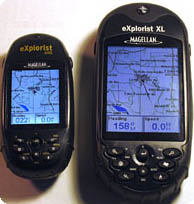
Compare Magellan explorist XL
and explorist 600![]()
The included Magellan Geocaching Manager software simplifies the fast-growing GPS activity by loading geocaching data directly from the Internet to the Magellan eXplorist to eliminate the need to print website information or manually enter GPS coordinates into a receiver. Also included is the new Magellan MapSend Software DVD, which makes it easier than ever for customers to take advantage of the power and advanced capabilities that MapSend maps add to their Magellan handheld. You'll receive free data management software plus the ability to purchase and install newly released versions of the MapSend line's most popular software applications directly from the DVD.
The biggest thing to hit outdoors navigation just got a whole lot bigger - thanks to the Magellan eXplorist XL. The eXplorist XL combines the ease-of-use and power of the eXplorist 500 with a 3.5" diagonal, sunlight viewable, high contrast color TFT LCD screen.
Adding to its ease of use are its backlit keypad and joystick that provides one-touch access to key features and built-in help files. Its advanced PC-style file management system and high-speed USB data port allows users to easily download and access compatible Magellan MapSend® mapping software.
GPS eXplorist Specification
| Technical Specifications | |
|---|---|
| Physical: | |
| Case: | Rubber armored impact-resistant plastic, water-resistant seal |
| Base Map: | None |
| Size: | 2.2" W x 4.7" H x 1.3" D (W 5.6 cm x H 11.9 cm x D 3.3 cm) |
| Weight: | 5.8 oz (164.4 g) - w/ batteries |
| Display: | 2.25" diagonal, 4-level grayscale, high resolution (122 x 160), backlit |
| Memory: | 4 MB user data |
| Data Storage: | None |
| Antenna: | Built-in multidirectional patch |
| Keypad: | Nine direct-access keys |
| Joystick: | Eight-way easy scrolling w/ push-in instant enter |
| Operating Range: | 14 to 140°F (-10 to 60°C) |
| Performance: | |
| Receiver: | TrueFixTM 14 channels, WAAS/EGNOS |
| Acquisition Time: | Hot: 20 seconds, Cold: 60 seconds, Initial: 2 minutes |
| Update Rate: | Once per second |
| Accuracy: | 3 to 5 meters (10 - 16 feet) - WAAS/EGNOS, < 7 meters (15 feet) - GPS only |
| Velocity: | 0.1 knots (RMS) |
| Dynamics: | 6 g |
| Grids: | 75 including Lat/Lon, UTM, OSGB,MGRS, Finnish, German, Swedish, French, Irish, Swiss, USNG, 1 User Grid (76 Max) |
| Languages: | English, French, German, Spanish, Italian, Swedish, Finnish, Portuguese, Dutch, Norwegian |
| Power: | |
| Source: | Two AA batteries |
| Battery Life: | Up to 18 hours continuous use |
More Magellan GPS related links:
Magellan Products - Auto, handhelds, fitness, portable gps devices and accessories.How GPS works? - A lot of details about GPS system.
GPS satellites - NAVSTAR, satellite constellation, USCG Navigation Center and more!
GPS Blog - Comment the latest news and info from gps arena
GPS Satellite Forum - Raise a topic with other GPS enthusiasts about products, software, applications or adventures.
GPS Unit Documentation and Manuals
Click onthe thumbnail to download
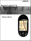
Explorist Magelan XL handheld GPS
Reference Manual
(PDF, 2,640K)