Iridium Satellites
Iridium satellite can support up to 1100 concurrent phone calls and weighs about 680 kg (1,500 lb). The Iridium satellite's constellation consists of 66 active and spares communication satellites around the Earth. It allows worldwide voice and data communications using handheld devices.![]()
Iridium Satellite Network
Initially, the Iridium satellite is placed in a circular orbit at an altitude of approximately 500 km. Normally, over a two week period the satellites are individually raised to a circular orbit of approximately 780 km. With its job done, the satellite dispenser at the 500 km altitude is placed in a lower eccentric orbit to accelerate decay and re-entry. During the first launch provided by Boeing's Delta II, the dispenser failed to achieve a lower eccentric orbit and went into a higher eccentric orbit.
This is one of 66 low-earth orbiting (LEO) satellites comprising the Iridium satellite system. The original company went bankrupt so the US Department of Defense assisted in making sure the system stayed in operation.
Satellite Constallation
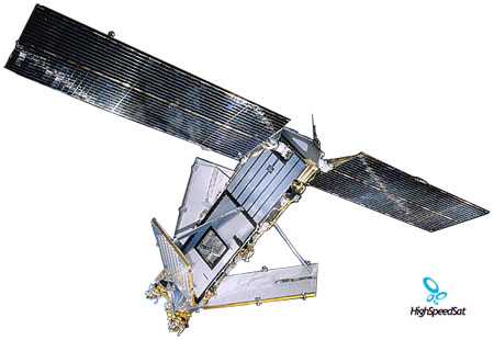
Iridium (Motorola) satellite design
The image of Iridium satellite on top of the page showing details of an exact replica of an Iridium satellite entirely built from spare parts.
Most of the structure seems to be made of honeycomb material covered with a layer of reflecting metal. So almost all flat surfaces of the satellite can produce flares. But, for now, only operational satellites can have flares predicted that come from the Main Mission Antennas (MMA) or the solar panels.
Triangular body of the satellite. We can easily notice the three MMAs with their white "beta cloth" covered upper surface. The battery compartment is in the upper section of the body but the cover is not visible since it is located on the surface facing the ceiling. This cover is highly reflective and tilted 5 to 10 degrees toward the ground. It's not a flat plate all the way, it has three angled surfaces unlike the other two sides. The white truss at the bottom is not part of the satellite.
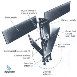
Iridium Satellite antennas
and design details ![]()
One of two solar panels. Because of their size, 8 meters total length, both could not be seen well on the same picture. See close-up in picture below.
Bottom view of the satellite showing well the MMA arrangement placed at 120 degrees apart. The four bronze dishes are the Gateway Antennas used to send the signals to the ground processing stations. Nice view of the satellite base showing all the antenna types including the three Crosslink Antennas, the flat plates about 30 cm in size, used to relay the signals between satellites of the constellation. Notice the white-sided square blocks on the MMAs. These are the receiving modules that collect signals from Iridium portable phones. Simulated flare on a MMA using the camera flash Close-up of the orientation mechanism for the solar arrays, again with a direct reflection of the camera flash. Notice the different cell colors. Details of the Gateway Antennas. Notice the surface texture on the MMA. One can imagine what a flare would be if it was a perfect mirrorHow the Iridium Network Works?
The Iridium satellite network includes three principal components which include the satellite network, the ground stations and the satellite phones and data units. Voice and data messages can be routed anywhere in the world by the Iridium network. Calls are relayed from the satellite phone or data unit on the ground to one of the Iridium satellites. It is then relayed from one satellite to another then down to an appropriate ground station. The call is then transferred to the public voice network or Internet when it reaches the recipient. The Iridium constellation includes 66 satellites flying in six orbital planes with 11 satellites equally spaced apart from each other in that orbital plane. The satellites have polar orbits at an altitude of 485 miles. The satellites communicate with each other using Ka-band intersatellite links. Each satellite has four intersatellite links, two to the fore and aft satellites in the same orbital plane and two to the satellites in orbital plane to either side. These intersatellite links allow calls to be routed among the Iridium satellites before being transferred to a ground station. This intersatellite links makes Iridium impervious to natural disasters like hurricanes or earthquakes which can damage a ground station. If a ground station is damaged the Iridium satellites can rout the call to another ground station. Each satellite completely orbits the earth in 100 minutes traveling at 16,832 miles per hour. From horizon to horizon it takes 10 minutes. As satellites move out of view from the satellite phone user the call is handed over to the next satellite coming into view. Each Iridium satellite contains seven Motorola Freescale PowerPC 603E processors running at 200MHz. One processor is dedicated to each cross link antenna and two processors are dedicated to satellite control with one as a spare. Each Iridium satellite can support up to 1100 phone calls. Communication with the Iridium network is done using a TDMA and FDMA based system using L band spectrum between 1616 and 1626.5MHz. Iridium controls 7.775MHz of this. The Iridium network uses three different types of handoff. When a satellite travels over the horizon the call is handed to adjacent spot beams. At the equator where the satellites are spaced the furthest apart, a satellite stays in view for seven minutes. This handoff may be noticeable by the satellite phone user by a quarter second gap in the call. The constellation is able to transfer the call to different channels and timeslots within the same spot beam. The Iridium gateways include the system control segment and telephony gateways used to connect into the public telephone system. As a satellite leaves the area of a ground station and looses it line-of-site, the routing tables change and frames are forwarded to the next satellite coming into view of the gateway. Gateways are located in Tempe, Arizona and Wahiawa, Hawaii. Like other satellite networks, Iridium satellite phones must have line-of-site to the sky in order to place a call. They will not work consistently indoors or under trees. There are fixed site units that include an external antenna giving you line-of-site for use on a building. There are also car kits giving you an external antenna.
Iridium Network Performance
Iridium operates the most reliable satellite constellation currently available. One of the reasons Iridium works so well is their system has more satellites than any other satellite provider, giving coverage to every part of the planet. With no service gaps, Iridium users can place and receive calls from virtually every part of the planet as long as they have line-of-site to one of the satellites. With cellular systems only covering 15 percent of the planet Iridium is the only wireless service available to many parts of the world.
Iridium Satellite Constellation
The Iridium satellite constellation is made up of 66 satellites with spares. The Iridium satellite network provides total worldwide voice and data communications using handheld and fixed site satellite phones. The Iridium satellite network is the only satellite network offering complete coverage of the whole earth including the poles and oceans.
The name Iridium comes from a chemical element by the same name. The original plan for the constellation was to have 77 satellites which are equal to the atomic number for the chemical Iridium.
Iridium is based in Bethesda, Maryland and is a privately held company. Iridium provides reliable, secure, mission critical satellite communications to and from any landline when cellular service is disrupted or not available.
Iridium constellation of 66 LEO satellites is the largest commercial satellite constellation in the world. The satellite constellation is cross-linked networked to be fully meshed leaving no gaps in service.
The Iridium satellite service provides communications to industries including aviation, government, military, emergency services, maritime, forestry, mining, oil and utilities. Among Iridiums largest customers is the U.S. Department of Defense (DOD) as well as civil and government agencies. Iridium is partnered with over 150 partners designing, building and selling its products and services around the world.
Iridium has operations in Tempe, Arizona and Leesburg, Virginia as well as a gateway in Hawaii; the U. S. DOD utilizes these for worldwide communications.
Iridium provides both voice and short burst data (SBD) satellite services. Voice services are provided by using handheld satellite phones as well as a variety of fixed and mobile satellite phones. Iridiums 9601 SBD transceiver provides data connections worldwide transferring email, weather, location information or any data requiring a two way connection.
Iridium has been a profitable company since 2004, growing at a very impressive rate due to increasing demand for reliable satellite communication worldwide. New customers and new partners have been constantly growing as they see the value of a worldwide satellite network that is reliable and guaranteed to work.
Iridium is also planning for the future by launching a plan called the NEXT initiative. This will be a new satellite constellation which will be fully operational by 2016.
Iridium Vision
Iridium is dedicated to provide mission critical satellite communications in more places than any other satellite communications provider worldwide. Iridium offers unique satellite communication covering every inch of the planet, connecting customers from anywhere to virtually everywhere in the world.
Iridiums current constellation should provide consistent service through 2014. They are planning what is called Iridium NEXT which will be their second generation replacement constellation of satellites. They plan to start launching these new satellites in 2013 to provide service through 2030. The Iridium NEXT will provide new capabilities including higher bandwidth as well as new devices and technology.
The Future of Iridium
In February of 2007 Iridium announced the program called "Iridium NEXT". The NEXT program will replace Iridiums current satellite constellation with a more power system. Iridium is doing this to insure high quality service for years to come due to an aging constellation. Suppliers for these new satellites are expected to be signed up sometime in 2008. The funding for the NEXT program will largely come from profits of the existing system.
The new 66 cross-linked satellites will be similar to the current system. There will be seamless backward compatibility to the current satellite phones. The new system will interface with power devices that will deliver more bandwidth. Several camera systems will be placed on the satellites providing real time low resolution images of the Earth to customers.
Iridium Satellite System Overview
The Iridium system is the only satellite system that provides true global coverage, including all ocean areas and Polar Regions, at all times. It provides a two-way, near-real time data communications capability, as all areas of the Earth are covered with at least one satellite. The Iridium system is a low-Earth Orbit (LEO) satellite network developed by Motorola® to provide personal mobile services. The original concept was visualized as far back as 1987 and was granted a full Federal Communications Commission (FCC) license in January of 1995 for construction and operation in the United States. The Iridium satellite network is now owned and operated by Iridium Satellite LLC (ISLLC). There are four components to the network: (1) a constellation of 66 satellites and 13 spares, (2) three terrestrial gateways, (3) a Satellite Network Operations Center (SNOC) and (4) Iridium Subscriber Units (ISU).
Please see http://www.nalresearch.com/QuickRef_NetworkDescription.html for a video showing the orbit of the Iridium satellites.
Each Iridium satellite is ~4 meters high and weighs ~667 kg fully fueled. Each satellite has three L-band antenna panels providing the 48 beams of footprint. The satellite has four 23 GHz cross-links antennas. These antennas point to the nearest spacecraft in the same plane (fore and aft) and in the two adjacent co-rotating planes. The feeder link antennas relay information to the terrestrial gateways. The spacecraft payload is the dominant component with high-speed digital switching to handle complex telephony routing.
The satellites are in six orbital planes separated by 31.6o at an altitude of 780 km and 86.4o inclination. The Iridium network is designed to operate in the L-band of 1616 to 1626.5 MHz for ground user links; in the Ka-band of 19.4 to 19.6 GHz and 29.1 to 29.3 GHz for gateway down- and up-links; and in the Ka-band of 23.18 to 23.38 GHz for Inter-Satellite Links (ISL). The exact L-band frequencies used depend on local regulating authorities and issued licenses in any particular region.
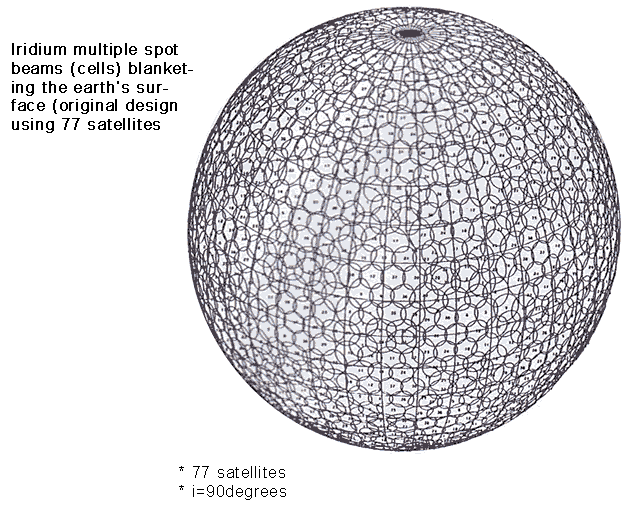
Each satellite projects 48 spot beams (which may be viewed as providing coverage cells on the ground similar to terrestrial cellular systems) on the surface of the Earth. Each beam is approximately 600 km in diameter. The 66-satellite constellation has the potential to support a total of 3,168 spot beams; however, as the satellite orbits converge at the poles, overlapping beams are shut down to prevent interferences. The satellite footprint is ~4,700 km in diameter. Under each footprint, a satellites power is limited to ~1,100 simultaneous circuits. A user is in view of a satellite for approximately nine minutes, with about one minute under each beam, before being handed-off to the next satellite.
Inter-satellite link or ISL is the network architecture employed by Iridium (versus bent-pipe employed by Globalstar and Orbcomm). A unique feature of the Iridium ISL capability is that the satellites not only can talk to ISU and gateways, but they can also talk to each other, forming a network aloft. When a signal is up-linked to a satellite by an ISU, it is down-linked immediately to a gateway located within the satellites footprint and then gets distributed to the final destination. However, when a gateway is not visible to the satellite, information is passed through the network of satellites to the one that is immediately over a gateway. Iridium ISL also allows ISUs to talk to each other without ever referencing to any ground stations at all, thereby reducing signal latency that can adversely affect time-sensitive protocols such as TCP/IP.
ISL provides benefits such as enhanced system reliability and capacity and reduces the number of gateways required. The greatest advantage of using ISL is essentially the capability of truly worldwide coverage without signal latency in either voice or data mode. By eliminating the dependency on ground infrastructure for traffic links, an ISL-based system such as Iridium becomes more autonomous. Moreover, ISL can make communications virtually impervious to terrestrial service disruptions that may be caused by earthquakes, hurricanes, floods and other natural and man-made causes.
There are currently two commercial Iridium gateways located in Tempe, Arizona, United States and Fucino, Italy. The U.S. Government/Department of Defense (DoD) selected Iridium for voice and data communications due, in large part, to its global coverage and secure systems architecture. The U.S. Government owns and operates a secure Iridium gateway, located in Hawaii. Each gateway generates and controls all user information pertaining to its registered users, such as user identity, geo-location and billing items. Gateways also provide connectivity from the Iridium system to the terrestrial-based networks such as the PSTN (Public Switched Telephone Network), DSN (Defense Switched Network), Internet, Misprint, etc. Although there are multiple gateways, a user is registered to a single gateway that will handle his data and voice communications.
An ISU can be either an Iridium satellite phone or any of Iridiums CDM and 9500/9505 series modems. It is capable of operating from 1616.0 to 1626.5 MHz; however, the actual frequencies used are in accordance with regional spectral licenses and international frequency coordination. An ISU (as well as Iridium satellites) uses Right Hand Circular Polarization (RHCP) and provides a maximum gain of 3.5 dBic from 8.2° to 90° elevation and a maximum gain of 0 dBic at 0° elevation. The average and peak RF transmitted powers are 0.6W and 7W, respectively.
The L-band interface between an ISU and an Iridium satellite is based on hybrid FDMA/TDMA (Frequency Division Multiple Access/Time Division Multiple Access) architecture using a 90 milli-second frame TDD (Time Division Duplex). The fundamental unit of the TDMA channel is a time-slot, which is organized into frames. A frame consists of a 20.32 milli-second downlink simplex time-slot, followed by four 8.2 milli-second uplink time-slots and four downlink time-slots with various guard times interspersed. Each frame is composed of 2250 symbols at the channel burst modulation rate of 25 kilo symbols per second (ksps).
Frequency accesses are divided into the duplex channel band and the simplex channel band. The duplex channel band is further divided into sub-bands, each occupying 333.333 kHz. In duplex operation, the Iridium network is capable of operating up to 30 sub-bands, containing a total of 240 frequency accesses. The Iridium system re-uses duplex channels from beam to beam when sufficient spatial isolation exists to avoid interference. A 12-frequency access band is reserved for the simplex channels. These channels are allocated in a globally allocated 500 kHz band between 1626.0 to 1626.5 MHz. The L-band downlink channels use DE-QPSK (Differentially Encoded Quaternary Phase Shift Keying) for traffic, broadcast, synchronization, ring alert and messaging. Power Spectral Flux Density (PSFD) provided to ISU ensures adequate service link margins. The uplink traffic channels use DE-QPSK modulation. The uplink acquisition and synchronization channels both use DE-BPSK (Differential Encoded Binary Phase Shift Keying). BPSK is used since it provides a 3 decibel (dB) link advantage, which improves the burst acquisition probability. Traffic channels operate with adaptive power control, which acts to limit power transmissions beyond what is required for a robust connection.
The L-band link between an ISU and Iridium satellite is designed for a threshold channel bit error of 0.02. The system operates with an average link margin of 13.1 dB above this level. Under good channel conditions, this level is reduced by adaptive power control. Even under adaptive power control, link margin is maintained to mitigate fades that are too short in duration to be compensated for by the power control loop. Adaptive power control uses a closed loop algorithm to adjust its transmitted power to the minimum value necessary to maintain high link quality. When the entire available link margin is not required to mitigate channel conditions, adaptive power control has the effect of reducing system power consumption.
The Iridium network makes calculations of the geographical location (geo-location) of an ISU each time a call is placed. This is done for billing purposes only. The technique employed to determine the geo-location of an ISU is based on measurements of the ISU, satellite propagation delay and Doppler frequency shift. These measurements are used to estimate cosines of spherical angles that identify the ISUs location relative to the satellite by the gateway. In the Iridium geo-location process, the ISU sends the satellite an uplink geo-location burst, saving the delay and Doppler corrections needed to send the message. When the satellite receives the uplink geo-location burst from the ISU, it measures the time and frequency offsets of the burst relative to its time and frequency standards. The satellite then responds with a downlink burst, which the ISU uses as an acknowledgement that the satellite has received the previous uplink geo-location burst. When the downlink burst arrives, the ISU checks to see if it is satisfied with its estimates for the timing and Doppler. If so, it then transmits an uplink Associated Control Channel, L-Band (ACCHL) message to the satellite that includes the propagation time and Doppler frequency offsets that were used by the ISU during the last geo-location uplink burst. If the ISU did not receive a response, or if the ISU is not satisfied with the accuracy of the exchange, the ISU will repeat the process again. The Iridium network can locate an ISU to within 10 km only about 78% of the time. The location accuracy can be much higher; however, the information is not available to commercial users. Geo-location errors in the east-west dimension, therefore, are sometimes more than 100 times greater than in the north-south dimension. However, DoD sponsored the development of the Iridium modem with an integrated GPS module to provide accurate location data independent of geo-positioning. The Iridium network supports Global System for Mobile Communications (GSM)-based algorithms for authentication and encryption to safeguard critical data to the satellites.
The satellites are in six orbital planes separated by 31.6o at an altitude of 780 km and 86.4o inclination. The Iridium network is designed to operate in the L-band of 1616 to 1626.5 MHz for ground user links; in the Ka-band of 19.4 to 19.6 GHz and 29.1 to 29.3 GHz for gateway down- and up-links; and in the Ka-band of 23.18 to 23.38 GHz for Inter-Satellite Links (ISL). The exact L-band frequencies used depend on local regulating authorities and issued licenses in any particular region.
INMARSAT ARSAT Satellite System Overview
The Inmarsat Satellite System is supported by a constellation of geostationary satellites that extend mobile phone, fax and data communications to every part of the world, except the poles and selected ocean areas. The satellites are controlled from Inmarsats headquarters in London, which is also home to Inmarsat Group Holdings Ltd, Inmarsats parent company, as well as a small Inter-Governmental Organization (IGO), the International Mobile Satellite Organization (IMSO), created to supervise the companys public-service duties to support the Global Maritime Distress and Safety System (GMDSS) and satellite-aided air traffic control for the aviation community.
Inmarsat came into being to provide global safety and other communications for the maritime community. Starting with a customer base of 900 ships in the early 1980s, it then grew rapidly to offer similar services to other users on land and in the air until, in 1999, it became the first IGO to be transformed into a private company. It now supports links for phone, fax and data communications to ship, vehicle, aircraft and other mobile users.
Inmarsats primary satellite constellation consists of four Inmarsat (I-3) satellites in geostationary orbit. These are currently backed up by a fifth spacecraft that can be brought in to provide additional capacity. Between them, the main global beams of the satellites provide overlapping coverage of the surface of the Earth apart from the Polar Regions and selected ocean areas. A geostationary satellite follows a circular orbit in the plane of the Equator at a height of 35,600 km, so that it appears to hover over a chosen point on the Earths surface. Three such satellites are enough to cover much of the Earths surface. The control teams at the Satellite Control Center (SSC) in London are responsible for keeping the satellites in position above the Equator and for ensuring that the onboard systems are fully functional at all times. Data on the status of the nine Inmarsat satellites is supplied to the SCC by four tracking, telemetry and control (TT&C) stations located at Fucino, Italy; Beijing, China; Lake Cowichan, western Canada; and Pennant Point, eastern Canada. There is also a back-up station at Eik in Norway. A call from an Inmarsat mobile terminal goes directly to the satellite overhead, which routes it back down to a gateway on the ground called a Land Earth Station (LES). From there the call is passed into the public phone network. The Inmarsat I-3 satellites are supported by four previous-generation Inmarsat-2s, also in geostationary orbit. A key advantage of the Inmarsat I-3s over their predecessors is their ability to generate a number of spot beams as well as single large global beams. Spot beams concentrate extra power in areas of high demand, as well as make possible the supply of standard services to smaller, simpler terminals. Launched in the early 1990s, the four second-generation Inmarsat I-2 satellites were built to Inmarsat specification by an international group headed by British Aerospace (now BAE Systems). The three-axis-stabilized Inmarsat I-2s were designed for a 10-year life. Inmarsat-2 F1 was launched in 1990 and is now located over the Pacific, providing lease capacity. F2, launched in 1991, is over the western Atlantic, providing leased capacity and backing up Inmarsat I-3 F4. Also orbited in 1991, F3 is stationed over the Pacific Ocean, providing lease capacity and backing up Inmarsat I-3 F3. The fourth Inmarsat-2 was launched in 1992 and is used to provide leased capacity over the Indian Ocean and backing up Inmarsat I-3 F1 and Inmarsat I-3 F3. Launched in 1996-8, the Inmarsat I-3s were built by Lockheed Martin Astro Space (now Lockheed Martin Missiles & Space) of the USA, responsible for the basic spacecraft, and the European Matra Marconi Space (now Astrium), which developed the communications payload. The Inmarsat I-3 communications payload can generate a global beam and a maximum of seven spot beams. The spot beams are directed as required to make extra communications capacity available in areas where demand from users is high. Inmarsat I-3 F1 was launched in 1996 to cover the Indian Ocean Region. Over the next two years F2 entered service over Atlantic Ocean Region-East, followed by F3 (Pacific Ocean Region), F4 (Atlantic Ocean Region-West) and F5 (limited services on a single spot beam, back-up and leased capacity). Responding to the growing demand from corporate mobile satellite users for high-speed Internet access and multimedia connectivity, Inmarsat has been building its fourth generation of satellites. The company awarded European spacecraft manufacturer Astrium the contract to build the three Inmarsat I-4 satellites. The job of the satellites will be to support the new Broadband Global Area Network (BGAN), currently scheduled to enter service in 2005 to deliver Internet and intranet content and solutions, video-on-demand, videoconferencing, fax, e-mail, phone and LAN access at speeds up to 432kbit/s almost anywhere in the world. BGAN will also be compatible with third-generation (3G) cellular systems. The satellites, the worlds largest commercial communications satellites, will be 100 times more powerful than the present generation and BGAN will provide at least 10 times as much communications capacity as todays Inmarsat network.