Triton 200 - Magellan GPS
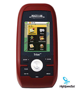
Magellan Triton 200 - Amazingly easy to use, it's the next-generation handheld GPS for precision outdoor navigation. Large, full-color display shows maps and data with crystal clear graphics. Rugged and waterproof (IPX-7).![]()
Other Magellan Triton Units:
TRITON 200 magellan ![]()
Rugged and waterproof, your Triton 200 is built to withstand intense use, accidental impact and immersion in one meter of water for up to 30 minutes (IPX-7). It's ready to guide you on any adventure.
The advanced features are also easy to use. View the elevation profile for the trail ahead (or any route). See the precise time of sunrise/sunset any day of the year. Get a calculation of the best hunting and fishing time. And much more.
Triton is built on the experience of GPS users over nearly 20 years of precision positioning technology from Magellan: the first name in navigation.
Magellan Satellite GPS
Optional (Purchase of Data Cable Required):
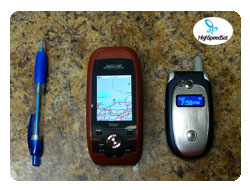
Magellan Triton200 - comparing ![]()
Exclusive VantagePoint software lets you easily manage user generated content, updates and upgrades on your PC. View saved routes and tracks. Customize them for future trips or create new ones.
Add detailed maps and applications to the available memory and further enhance your navigation experience. Plus, Triton is the first handheld GPS to offer compatibility with National Geographic maps. These highly detailed nation-wide topographic maps based on USGS 1:24.000 series quads, offer seamless scalability, multi-layer overlays and much more.
Magellan Triton Specification
| Technical Specifications | |
|---|---|
| Physical: | |
| Case: | Rubber armored impact-resistant plastic, water-resistant seal, IPX-7 |
| Base Map: | Built-in basemap of Contiguous U.S., Alaska, Canada and Worldwide Geographic Boundaries |
| Size: | "4.65" x 2.16" x 1.22" |
| Weight: | 6.6 oz (187.1 g) - w/ battery |
| Display: | 2.2" (5.59cm) diagonal, QVGA (240 x 320) resolution, LED backlit |
| Memory: | 10 MB |
| Antenna: | Built-in multidirectional patch |
| Keypad: | Nine direct-access keys |
| Operating Range: | 14 to 140°F (-10 to 60°C) |
| Performance: | |
| Receiver: | TrueFix 14 channels, WAAS/EGNOS |
| Acquisition Time: | Hot: 20 seconds, Cold: 60 seconds, Initial: 2 minutes |
| Update Rate: | Once per second |
| Accuracy: | 3 to 5 meters (10 - 16 feet) - WAAS/EGNOS, < 7 meters (15 feet) - GPS only |
| Languages: | English and French |
| Coordinate Systems: | Latitude/Longitude and UTM |
| Power: | |
| Source: | Two AA Batteries (not included) |
| Battery Life: | 10 hours |
More Magellan GPS related links:
Magellan Products - Auto, handhelds, fitness, portable gps devices and accessories.How GPS works? - A lot of details about GPS system.
GPS satellites - NAVSTAR, satellite constellation, USCG Navigation Center and more!
GPS Blog - Comment the latest news and info from gps arena
GPS Satellite Forum - Raise a topic with other GPS enthusiasts about products, software, applications or adventures.
GPS Unit Documentation and Manuals
Click on the thumbnail to download
Triton Magelan 200 GPS
Product Sheet
(PDF, 507K)
Click on the thumbnail to download
Triton 200 GPS
User Manual
(PDF, 1,534K)