Geostationary Satellite
Geostationary/geosynchronous csatellites have revolutionized global communications (phone, internet) and TV broadcasting. ![]()
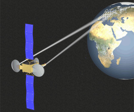
A geostationary satellite is an earth-orbiting satellite, placed at an altitude of approximately 35,800 kilometers (22,300 miles) directly over the equator, that revolves in the same direction the earth rotates (west to east). At this altitude, one orbit takes 24 hours, the same length of time as the earth requires to rotate once on its axis. The term geostationary comes from the fact that such a satellite appears nearly stationary in the sky as seen by a ground-based observer.
A single geostationary satellite is on a line of sight with about 40 percent of the earth's surface. Three such satellites, each separated by 120 degrees of longitude, can provide coverage of the entire planet, with the exception of small circular regions centered at the north and south geographic poles. A geostationary satellite can be accessed using a directional antenna, usually a small dish, aimed at the spot in the sky where the satellite appears to hover. The principal advantage of this type of satellite is the fact that an earthbound directional antenna can be aimed and then left in position without further adjustment. Another advantage is the fact that because highly directional antennas can be used, interference from surface-based sources, and from other satellites, is minimized.
Derivation of geostationary altitude
In any circular orbit, the centripetal acceleration required to maintain the orbit is provided by the gravitational force on the satellite. To calculate the geostationary orbit altitude, one begins with this equivalence, and uses the fact that the orbital period is one sidereal day.
By Newton's second law of motion, we can replace the forces F with the mass m of the object multiplied by the acceleration felt by the object due to that force:
We note that the mass of the satellite m appears on both sides geostationary orbit is independent of the mass of the satellite. So calculating the altitude simplifies into calculating the point where the magnitudes of the centripetal acceleration required for orbital motion and the gravitational acceleration provided by Earth's gravity are equal.
The centripetal acceleration's magnitude is:
where ? is the angular speed, and r is the orbital radius as measured from the Earth's center of mass.
The magnitude of the gravitational acceleration is:
where M is the mass of Earth, 5.9736 × 1024 kg, and G is the gravitational constant, 6.67428 ± 0.00067 × 10⁻¹¹ m3 kg-1 s-2.
Equating the two accelerations gives:
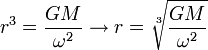
The product GM is known with much greater accuracy than either factor; it is known as the geocentric gravitational constant µ = 398,600.4418 ± 0.0008 km3 s-2:
The angular speed ? is found by dividing the angle travelled in one revolution (360° = 2p rad) by the orbital period (the time it takes to make one full revolution: one sidereal day, or 86,164.09054 seconds).[3] This gives:
The resulting orbital radius is 42,164 kilometres (26,199 mi). Subtracting the Earth's equatorial radius, 6,378 kilometres (3,963 mi), gives the altitude of 35,786 kilometres (22,236 mi). Orbital speed (how fast the satellite is moving through space) is calculated by multiplying the angular speed by the orbital radius:
Orbite alocation
Satellites in geostationary orbit must all occupy a single ring above the equator. The requirement to space these satellites apart means that there are a limited number of orbital "slots" available, thus only a limited number of satellites can be placed in geostationary orbit. This has led to conflict between different countries wishing access to the same orbital slots (countries at the same longitude but differing latitudes). These disputes are addressed through the International Telecommunication Union's allocation mechanism.[5] Countries located at the Earth's equator have also asserted their legal claim to control the use of space above their territory.[6] Since the Clarke Orbit is about 265,000 km (165,000 mi) long, countries and territories in less-populated parts of the world have been allocated slots already, even though they aren't used, yet. The problem presently lies over densely-populated areas such as the Americas and Europe/Africa, and above the middles of the three equatorial oceans.
Orbit Inclination
If a geosynchronous satellite's orbit is not exactly aligned with the equator, the orbit is known as an inclined orbit. It will appear (when viewed by someone on the ground) to oscillate daily around a fixed point in the sky. As the angle between the orbit and the equator decreases, the magnitude of this oscillation becomes smaller; when the orbit lies entirely over the equator, the satellite remains stationary relative to the Earth's surface it is said to be geostationary.
Impact on signals
Satellites in geostationary orbits are far enough away from Earth that communication latency becomes very high about a quarter of a second for a one-way trip from a ground based transmitter to a geostationary satellite and back, and close to half a second for round-trip end-to-end communication.
For example, for ground stations at latitudes of f=±45° on the same meridian as the satellite, the one-way delay can be computed by using the cosine rule, given the above derived geostationary orbital radius r, the Earth's radius R and the speed of light c, as
This presents problems for latency-sensitive applications such as voice communication or online gaming.
Application
There are approximately 300 operational geosynchronous satellites. Geostationary satellites appear to be fixed over one spot above the equator. Receiving and transmitting antennas on the earth do not need to track such a satellite. These antennas can be fixed in place and are much less expensive than tracking antennas. These satellites have revolutionized global communications, television broadcasting and weather forecasting, and have a number of important defense and intelligence applications.
One disadvantage of geostationary satellites is a result of their high altitude: radio signals take approximately 0.25 of a second to reach and return from the satellite, resulting in a small but significant signal delay. This delay increases the difficulty of telephone conversation and reduces the performance of common network protocols such as TCP/IP, but does not present a problem with non-interactive systems such as television broadcasts. There are a number of proprietary satellite data protocols that are designed to proxy TCP/IP connections over long-delay satellite links -- these are marketed as being a partial solution to the poor performance of native TCP over satellite links. TCP presumes that all loss is due to congestion, not errors, and probes link capacity with its "slow-start" algorithm, which only sends packets once it is known that earlier packets have been received. Slow start is very slow over a path using a geostationary satellite.
Another disadvantage of geostationary satellites is the incomplete geographical coverage, since ground stations at higher than roughly 60 degrees latitude have difficulty reliably receiving signals at low elevations. Satellite dishes in the Northern Hemisphere would need to be pointed almost directly towards the horizon. The signals would have to pass through the largest amount of atmosphere, and could even be blocked by land topography, vegetation or buildings. In the USSR, a practical solution was developed for this problem with the creation of special Molniya / Orbita inclined path satellite networks with elliptical orbits. Similar elliptical orbits are used for the Sirius Radio satellites.
Geostationary satellites have two major limitations. First, because the orbital zone is an extremely narrow ring in the plane of the equator, the number of satellites that can be maintained in geostationary orbits without mutual conflict (or even collision) is limited. Second, the distance that an electromagnetic (EM) signal must travel to and from a geostationary satellite is a minimum of 71,600 kilometers or 44,600 miles. Thus, a latency of at least 240 milliseconds is introduced when an EM signal, traveling at 300,000 kilometers per second (186,000 miles per second), makes a round trip from the surface to the satellite and back.
There are two other, less serious, problems with geostationary satellites. First, the exact position of a geostationary satellite, relative to the surface, varies slightly over the course of each 24-hour period because of gravitational interaction among the satellite, the earth, the sun, the moon, and the non-terrestrial planets. As observed from the surface, the satellite wanders within a rectangular region in the sky called the box. The box is small, but it limits the sharpness of the directional pattern, and therefore the power gain, that earth-based antennas can be designed to have. Second, there is a dramatic increase in background EM noise when the satellite comes near the sun as observed from a receiving station on the surface, because the sun is a powerful source of EM energy. This effect, known as solar fade, is a problem only within a few days of the equinoxes in late March and late September. Even then, episodes last for only a few minutes and take place only once a day.