eXplorist 400 - Magellan GPS
The Magellan eXplorist400 - features mapping capabilities and unlimited storage via optional secure digital (SD) cards so you can take as many maps with you as you want to. Add detailed street maps, topo or lake maps using optional Magellan MapSend software.![]()
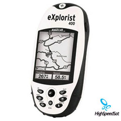
Get the powerful, expandable mapping pocket-sized GPS. The Magellan® eXplorist 400 features mapping capabilities and unlimited storage via optional secure digital (SD) cards so you can take as many maps with you as you want to. Add detailed street maps, topo or lake maps using optional Magellan MapSend software. The high-speed USB data port makes downloading information easy and the Geocache Manager software enables you to download caches directly to your eXplorist 400. eXplorist 400 has 8 MB of built-in maps and 8 MB of internal memory to save 5 track log files, 20 routes and 500 points of interest, but you can save as many as you need to optional SD cards. Slip your compact (2.1 in x 4.6 in) eXplorist 400 into your pocket and let it guide you on every outdoor adventure. Magellan TrueFix™ technology provides superior accuracy and reliability, giving you the freedom to explore without concern of getting lost.
The eXplorist 400 is Magellan's newest pocket-sized wonder with expandable SD memory. This handheld features a monochrome "amber glow" backlight display making it safe to navigate even at night. The eXplorist 400 includes Magellan's TrueFix technology, which means you will get a 14 parallel channel WAAS GPS receiver. TrueFix technology will allow excellent acquisition times, superb tracking with minimal signal loss and 3-meter accuracy. If youre are a hiker, hunter, boater, geocacher or all of the above, the eXplorist 400 is perfect with its small and lightweight design and advanced features.
EXPLORIST 400 device
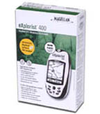
in the box ![]()
The eXplorist 400 has an 8MB basemap with major roads as well as major Points of Interest, and can be expanded with the purchase of compatible Magellan Mapsend software and a SD memory card. The eXplorist 400 can use the SD card to store maps as well as an unlimited amount of waypoints, track logs, and routes.
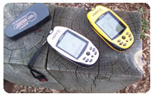
Magellan gps models
400 & 200![]()
The eXplorist 400 has a Li-Ion rechargeable battery pack that can provide up to 17-hours of use and comes with a USB interface cable so you can transfer information at high speeds. Just like the rest of the eXplorist line, Magellan has made the operation simple so just about anyone can use it.
There is even a Geocache Manager to easily manage your geocaching coordinates. The eXplorist 400 is built for all outdoor adventures with its waterproof casing, rubber armor and impact resistant plastic. Other features include Area Calculation function, 10 Languages, and four navigation screens.
eXplorist 400 GPS Reviews
TrueFix GPS technology takes advantage of 14 parallel channels, supported by WAAS and EGNOS Satellite-Based Augmentation Systems for fast signal acquisition, minimal signal loss and reliable accuracy to within 3 meters.
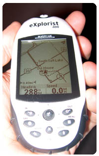
eXplorist-400 white
handheld GPS system
![]()
Want to find the distance between three or more points of interest that you plan to hike around or the area between them? Simply select the points of interest on the map and the eXplorist can determine the area between them and the perimeter around them.
This Li-Ion rechargeable battery pack can keep your eXplorist continuously powered-up for up to 14 hours. Recharge your battery directly through your receiver again and again without reducing its performance.
Your eXplorist 400 features SD card compatibility for unlimited memory expansion. Use optional Magellan MapSend software to add detailed street maps, topo or marine charts to any number of SD memory cards (sold separately). Your eXplorist 400 features SD card compatibility for unlimited memory expansion. Use optional Magellan MapSend software to add detailed street maps, topo or marine charts to any number of SD memory cards (sold separately).
Get the powerful, expandable mapping pocket-sized GPS. Your Magellan eXplorist 400 Portable Navigator features built-in mapping and unlimited storage using optional secure digital (SD) cards so you can take as many maps with you as you want to. Add detailed street maps, topo or lake maps using optional Magellan MapSend software. The high-speed USB data port makes downloading information easy and Geocache Manager software enables you to download caches directly to your GPS.
GPS eXplorist Specification
| Technical Specifications | |
|---|---|
| Physical: | |
| Case: | Rubber armored impact-resistant plastic, water-resistant seal |
| Base Map: | 16 MB Built-in basemap of North America or Europe |
| Size: | 2.2" W x 4.7" H x 1.3" D (W 5.6 cm x H 11.9 cm x D 3.3 cm) |
| Weight: | 5.4 oz (153 g) - w/ battery |
| Display: | 2.25" diagonal, 4-level grayscale, high resolution (122 x 160), backlit |
| Memory: | 16 MB user data |
| Data Storage: | Unlimited / Secure Digital (SD) Card compatible |
| Antenna: | Built-in multidirectional patch |
| Keypad: | Nine direct-access keys |
| Joystick: | Eight-way easy scrolling w/ push-in instant enter |
| Operating Range: | 14 to 140°F (-10 to 60°C) |
| Performance: | |
| Receiver: | TrueFixTM 14 channels, WAAS/EGNOS |
| Acquisition Time: | Hot: 20 seconds, Cold: 60 seconds, Initial: 2 minutes |
| Update Rate: | Once per second |
| Accuracy: | 3 to 5 meters (10 - 16 feet) - WAAS/EGNOS, < 7 meters (15 feet) - GPS only |
| Velocity: | 0.1 knots (RMS) |
| Dynamics: | 6 g |
| Grids: | 75 including Lat/Lon, UTM, OSGB,MGRS, Finnish, German, Swedish, French, Irish, Swiss, USNG, User Grid (90 Max) |
| Languages: | English, French, German, Spanish, Italian, Swedish, Finnish, Portuguese, Dutch, Norwegian |
| Power: | |
| Source: | Li-Ion rechargeable battery 1300 MAH |
| Battery Life: | Up to 17 hours continuous use |
More Magellan GPS related links:
Magellan Products - Auto, handhelds, fitness, portable gps devices and accessories.How GPS works? - A lot of details about GPS system.
GPS satellites - NAVSTAR, satellite constellation, USCG Navigation Center and more!
GPS Blog - Comment the latest news and info from gps arena
GPS Satellite Forum - Raise a topic with other GPS enthusiasts about products, software, applications or adventures.
GPS Unit Documentation and Manuals
Click onthe thumbnail to download
Explorist Magelan 400 GPS
Reference Manual
(PDF, 2,631K)