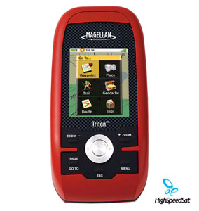
Triton 500 - Magellan GPS
Magellan Triton 500 - Advanced full-color navigation that's amazingly easy! 3-axis electronic compass and built-in barometer offer enhanced navigation capabilities. SD-card compatibility enables use of unlimited optional detailed maps and other user generated content. Rugged and waterproof to take you anywhere![]()
Other Magellan Triton Units:
Magellan Triton reinvents handheld GPS. Amazingly easy to use, Triton 500 is perfect for the first-time GPS user. And the full-color display, SD-card compatibility, enhanced features, fast signal acquisition, reliable signal lock and precision positioning make Triton 500 an excellent choice for the advanced navigator.
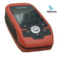
Magellan Triton 500 - sideview ![]()
The smartly designed interface with simple menus and intuitive button and scroll pad control make navigation fun and effortless. The full-color crystal clear display shows all your maps and navigation information in brilliant, easy-to-view graphics. Instantly see all your maps, locations and saved tracks and waypoints with just a click or two. Unlike other complicated devices that require you to scroll through page after page, Triton 500 gets you to the information you want with a few keystrokes.

Magellan Triton 500 Handheld Navigation System![]()
Magellan Satellite GPS
Exclusive VantagePoint software enables easy management of maps, user generated content, updates and upgrades on your PC. View saved routes and tracks. Customize them for future trips or create new ones.
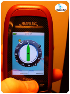
Electronic compass in Magellan
Triton 500![]()
Triton is designed for precision navigation, offering the fastest GPS positioning acquisition in the industry with the SiRFstarIII chipset. An integrated high-sensitivity antenna provides reliable signal reception even in heavy cloud cover, canyons or deep woods. Built-in signal augmentation reception (WAAS/EGNOS) provides 3-meter accuracy.
Rugged and waterproof, your Triton 500 is built to withstand intense use, accidental impact and immersion in one meter of water for up to 30 minutes (IPX-7). It's ready to guide you on any adventure.
The advanced features are also easy to use. View the elevation profile for the trail ahead (or any route) or even the track you just traveled. See the precise time of sunrise/sunset any day of the year. Get a calculation of the best hunting and fishing time. And much more.
Triton is built on the experience of hundreds of thousands of GPS users and nearly 20 years of precision positioning technology from Magellan: the first name in navigation.
Magellan Triton Specification
| Technical Specifications | |
|---|---|
| Physical: | |
| Case: | Rubber armored impact-resistant plastic, water-resistant seal, IPX-7 |
| Base Map: | Built-in basemap of Contiguous U.S., Alaska, Canada and Worldwide Geographic Boundaries |
| Size: | "4.65" x 2.16" x 1.22" |
| Weight: | 6.6 oz (187.1 g) - w/ battery |
| Display: | 2.2" (5.59cm) diagonal, QVGA (240 x 320) resolution, LED backlit |
| Memory: | SD Card |
| Data Storage: | Secure Digital (SD) Card |
| Antenna: | Built-in multidirectional patch |
| Keypad: | Nine direct-access keys |
| Operating Range: | 14 to 140°F (-10 to 60°C) |
| Performance: | |
| Receiver: | TrueFix 14 channels, WAAS/EGNOS |
| Acquisition Time: | Hot: 20 seconds, Cold: 60 seconds, Initial: 2 minutes |
| Update Rate: | Once per second |
| Accuracy: | 3 to 5 meters (10 - 16 feet) - WAAS/EGNOS, < 7 meters (15 feet) - GPS only |
| Languages: | English and French |
| Coordinate Systems: | Latitude/Longitude and UTM |
| Power: | |
| Source: | Two AA Batteries (not included) |
| Battery Life: | 10 hours |
More Magellan GPS related links:
Magellan Products - Auto, handhelds, fitness, portable gps devices and accessories.How GPS works? - A lot of details about GPS system.
GPS satellites - NAVSTAR, satellite constellation, USCG Navigation Center and more!
GPS Blog - Comment the latest news and info from gps arena
GPS Satellite Forum - Raise a topic with other GPS enthusiasts about products, software, applications or adventures.
GPS Unit Documentation and Manuals
Click on the thumbnail to download
Triton Magelan 500 GPS
Product Sheet
(PDF, 527K)
Click on the thumbnail to download
Triton 500 GPS
User Manual
(PDF, 1,534K)